Drone mapping has revolutionized the way we explore and map the world around us.
In this article, we’ll delve into what drone mapping is and how it differs from traditional mapping methods.
We’ll also explore the crucial role of drone pilots, the job opportunities available to them, and the skills required for success.
We’ll discuss the benefits of using drones for mapping, the challenges they face, and how to become a certified drone pilot.
We’ll look at the future of drone mapping, including advancements in technology and the increased demand for skilled drone pilots.
Join us as we chart new horizons with the rise of drone mapping.
Drone Mapping has become a fast growing segment of the drone industry!
Learn the necessary skills for complex aerial mapping projects.
Click Here For The Drone Mapping Essentials Online Course
Key Takeaways:
- Drone mapping is a cost-effective and time-saving method for collecting high-quality and detailed data.
- Drone pilots have increased opportunities for jobs and the need for specific skills in drone technology and mapping software.
- The future of drone mapping looks promising, with advancements in technology and an increasing demand for skilled drone pilots.
What is Drone Mapping?
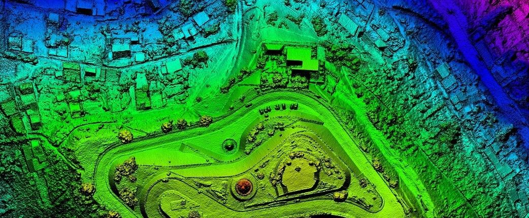
Drone mapping refers to the process of using drones to capture aerial images and data of an area for mapping and surveying purposes. It involves the integration of aerial photogrammetry techniques to create accurate maps and models of the terrain.
This innovative technology has revolutionized traditional mapping and surveying methods, offering unparalleled efficiency and precision. Through the use of drones equipped with high-resolution cameras, geospatial professionals can collect vast amounts of data quickly and cost-effectively. The data captured from drone mapping missions can be processed using specialized software to generate detailed 2D maps and 3D models of landscapes, buildings, and infrastructure.
How is Drone Mapping Different from Traditional Mapping Methods?
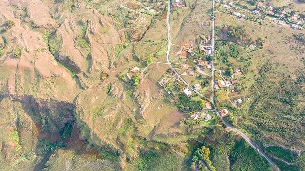
Drone mapping differs from traditional mapping methods by leveraging drones equipped with advanced sensors and cameras to capture high-resolution images and data from above. This aerial data collection approach provides quicker, more detailed, and cost-effective mapping results compared to traditional ground-based surveys.
One of the key advantages of drone mapping is its ability to access hard-to-reach or hazardous areas that might be challenging for traditional mapping techniques. Drones can fly over terrains that are difficult for humans to traverse, making them ideal for mapping in remote or inaccessible locations. The use of drones in mapping significantly reduces the time needed to complete a survey, as they can cover large areas efficiently and with higher accuracy.
Drone Mapping has become a fast growing segment of the drone industry!
Learn the necessary skills for complex aerial mapping projects.
Click Here For The Drone Mapping Essentials Online Course
The Role of Drone Pilots in Aerial Photogrammetry
Drone pilots play a crucial role in collecting aerial data for various applications such as surveying, mapping, and monitoring. Their expertise in operating drones equipped with AI and advanced mapping software from companies like Drone Deploy and Pix4D is instrumental in capturing accurate data.
Drone mapping requires a unique set of skills to navigate drones effectively, ensuring precise data collection in diverse terrains and conditions. The ability to understand the intricacies of drone flight patterns and camera angles is critical for acquiring high-quality images and data for drone photogrammetry.
What are the Job Opportunities for Drone Mapping?
Job opportunities for people with drone mapping skills are vast and diverse, ranging from conducting aerial surveys for construction projects to mapping archaeological sites for research purposes.
With the increasing demand for drone technology, drone pilots can find rewarding careers in environmental conservation, agriculture, construction, forestry, inspections, land surveying, mining, real estate, urban planning & infrastructure development, emergency management, and even entertainment industries.
In environmental monitoring, they can assist in tracking wildlife populations and identifying potential threats to ecosystems. For emergency disaster response, drone pilots play a crucial role in assessing damages and locating survivors after natural disasters. In the entertainment industry, drones are used for aerial filming and capturing stunning cinematic shots.
What Skills are Required for Drone Mapping?
Drone pilots need to develop the technical skills required to use specialized aerial photogrammetry software for 3D mapping in order to generate accurate maps. Proficiency in GIS software and data analysis tools is essential for processing the collected data effectively.
Drone pilots must possess a deep understanding of drone regulations and safety protocols to ensure compliant and secure operations. Having a keen eye for detail is crucial when analyzing aerial imagery and identifying patterns or anomalies. Communication skills are also vital, as drone pilots often collaborate with project managers, engineers, and other stakeholders to translate data insights into actionable plans.
The Benefits of Using Drones for Mapping
Using drones for mapping provides several advantages, including cost-effectiveness, time-saving data collection, access to remote and hazardous areas, and the ability to capture high-quality, detailed imagery for accurate mapping and surveying applications.
One key benefit of utilizing drones in mapping is the significant cost savings they offer. Traditional mapping methods often require substantial financial investment in equipment, personnel, and resources. In contrast, drones can efficiently cover large areas with minimal operational costs, making mapping projects more affordable.
Along with cost savings, drones enhance efficiency in mapping activities. They can swiftly collect data from various perspectives, reducing the time required for data acquisition and processing. This accelerated workflow not only speeds up mapping projects but also improves overall project timelines.
Drone Mapping has become a fast growing segment of the drone industry!
Learn the necessary skills for complex aerial mapping projects.
Click Here For The Drone Mapping Essentials Online Course
Drones provide access to challenging terrains that are difficult or dangerous to reach using conventional methods. They can navigate rugged landscapes, dense forests, or inaccessible locations, allowing for comprehensive mapping of such areas with enhanced safety and precision.
Another advantage of drone mapping is the superior data quality it delivers. By utilizing advanced technologies such as AI and mapping software like Pix4D, drones can capture highly detailed and accurate imagery. This rich dataset enables more precise mapping results, benefiting various industries from urban planning to environmental conservation.
Cost-Effective
One of the key benefits of using drones for mapping is their cost-effectiveness, as they offer a more economical alternative to traditional aerial surveys or ground-based mapping methods.
By utilizing drones, companies can significantly reduce expenses associated with hiring manned aircraft, which tend to be much more costly to operate. The operational efficiencies of drones allow for swift and precise data collection, enhancing overall productivity. These streamlined processes not only lead to substantial cost savings but also provide more accurate and detailed mapping results.
Time-Saving
Drones expedite the mapping process by significantly reducing the time required for data acquisition and processing, enabling rapid generation of maps and models for timely decision-making.
By employing drones in mapping operations, teams can accomplish in hours what would traditionally take days or even weeks. The speed at which drones collect data is unmatched, swiftly covering vast terrains and capturing intricate details with precision. This efficiency not only streamlines the mapping process but also allows for greater accuracy in the results obtained. With faster data turnaround, organizations leverage cutting-edge technologies like AI to enhance data analysis and unlock insights that drive informed decisions.
Access to Remote and Dangerous Areas
Drones provide access to remote and hazardous environments that are challenging for traditional surveying teams, allowing exploration activities to be conducted safely and efficiently in areas with limited accessibility.
The utilization of drones has revolutionized the way mapping is done in such secluded regions. By incorporating advanced technologies, these unmanned aerial vehicles ensure unparalleled safety while collecting vital data for analysis and decision-making. Companies like DSLR Pros and Red Cat have been at the forefront of developing cutting-edge drones that can navigate even the most treacherous terrains effortlessly. These drones have the capability to reach depths and heights that would pose significant risks to human surveyors, making them invaluable tools for exploratory missions.
High-Quality and Detailed Data Collection
Drones deliver high-quality and detailed data for mapping applications, capturing precise imagery and measurements that enable the creation of accurate maps, 3D models, and Geographic Information Systems (GIS) datasets.
Utilizing advanced technologies like Real-Time Kinematic (RTK) GPS systems, drones can achieve centimeter-level accuracy in data collection, ensuring the highest possible precision. The data gathered by these UAVs boast exceptional resolution, allowing for the identification of minute details in terrain and infrastructure. The integration of this high-quality data into GIS platforms enhances spatial analysis and decision-making processes across various industries, from urban planning to environmental monitoring.
The Challenges of Drone Mapping
Despite its benefits, drone mapping faces challenges such as technical limitations, regulatory hurdles, and environmental concerns that impact the effective use of drones for mapping and surveying activities.
Technical limitations in drone mapping often revolve around issues like battery life, flight time, and payload capacity. These constraints can limit the range and accuracy of data that drones can collect, affecting the overall quality of mapping results.
Regulatory hurdles play a significant role in drone mapping as well, with restrictions on flight altitudes, no-fly zones, and licensing requirements varying from region to region. Navigating these legal frameworks adds complexity and can hinder the seamless deployment of drones in mapping projects.
Environmental concerns pose a challenge, particularly in sensitive ecosystems where drone operations may disturb wildlife or contribute to noise pollution. Balancing the benefits of drone mapping with minimizing environmental impact requires careful planning and adherence to best practices.
Technical Limitations
Drone mapping encounters technical limitations related to battery life, payload capacity, and image processing capabilities, affecting the efficiency and scope of mapping operations.
These challenges are intrinsic to the nature of drone mapping operations, as drones are required to carry sophisticated sensors and cameras which demand significant power, resulting in battery constraints that restrict flight duration. Moreover, payload limitations pose restrictions on the types of sensors and equipment that can be utilized during mapping missions, impacting data collection quality. Additionally, processing bottlenecks come into play when vast amounts of high-resolution images need to be stitched together and analyzed, often requiring powerful computers and software such as Trimble to manage the data efficiently.
Regulatory Hurdles
Drone mapping encounters regulatory hurdles such as airspace restrictions, licensing requirements, and privacy concerns that govern the legal operation of drones.
Airspace regulations play a crucial role in determining where drones can fly, especially concerning no-fly zones and altitude restrictions. Navigating through these regulations is essential to ensure safety and compliance.
- Licensing constraints add another layer of complexity as operators need to acquire the proper permits from regulatory bodies like the FAA.
- Privacy considerations highlight the need to protect sensitive data and respect individuals’ rights in the era of advanced drone mapping technologies.
Overcoming these challenges requires a thorough understanding of the legal landscape and collaboration with governmental entities such as the FAA and GIS authorities. Compliance with evolving regulations is key to unlocking the full potential of drone mapping in various industries.
Environmental Concerns
Drone mapping raises environmental concerns related to noise pollution, wildlife disturbance, and ecological impacts that must be addressed to minimize the environmental footprint of drone operations in mapping missions.
Exyn Technologies, a leader in autonomous drone systems, is at the forefront of developing innovative solutions that prioritize ecological considerations while utilizing cutting-edge AI technology. By optimizing flight paths and employing advanced algorithms, these drones can operate with reduced noise levels, minimizing disruption to surrounding wildlife and ecosystems.
The integration of AI enables drones to collect data more efficiently, thereby reducing the time spent in environmentally sensitive areas. This approach not only benefits the environment but also enhances the accuracy and effectiveness of drone mapping initiatives.
How to Become a Certified Drone Pilot
Becoming a certified drone pilot requires obtaining a Remote Pilot Certificate from the Federal Aviation Administration (FAA) that validates your knowledge and skills in operating drones for commercial purposes.
Acquiring this certification involves passing an exam that covers various topics such as airspace classification, weather effects, flight restrictions, and emergency procedures. Click through to How Do I Become a Drone Pilot for your next steps.
Preparation for the exam requires thorough study of the FAA’s Remote Pilot – Small Unmanned Aircraft Systems Study Guide to ensure a comprehensive understanding of the rules and regulations.
Completing an online training course from an FAA-approved provider is highly recommended to enhance your knowledge and readiness for the exam.
Developing a strong skill set in aerial photography, mapping techniques, and regulatory compliance will not only enhance your chances of success but also open up avenues to collaborate on exciting projects.
Gain Experience with Drone Technology and Mapping Software
Building expertise in drone technology and mapping software such as Pix4D and Drone Deploy is essential in order to master data collection, processing, and analysis techniques required for mapping projects. Leveraging these advanced tools not only enhances efficiency but also allows for seamless integration of data collection into precise mapping analyses.
By immersing yourself in the practical application of drone technology and cutting-edge mapping software, you can gain valuable hands-on experience that is crucial for successful navigation of complex mapping projects.
Network with Companies and Organizations
Networking with companies and organizations plays a vital role for drone pilots seeking opportunities in the field, as it allows you to showcase your skills, expertise, and portfolio to potential employers. Join online forums, attend industry events, and collaborate with experts to expand your knowledge and opportunities.
One of the best ways for drone pilots to network effectively is by actively engaging with industry professionals through social media platforms such as LinkedIn, where you can join relevant groups, participate in discussions, and connect with key figures.
The Future of Drone Mapping
The future of drone mapping looks promising, with advancements in technology driving the expansion of drone mapping applications, increasing demand for skilled drone pilots, and paving the way for innovative solutions in data collection and analysis.
Technological innovations such as high-resolution cameras, LiDAR sensors, and powerful software are enabling drones to capture detailed aerial imagery and create precise maps, revolutionizing the way projects are carried out.
- Drone mapping is not only improving efficiency and safety but also providing valuable insights for various industries, ranging from agriculture and construction to environmental conservation and emergency management.
- The integration of drones with Geographic Information Systems (GIS) is enhancing the capabilities of spatial data analysis, allowing for more accurate decision-making processes and resource management strategies.
Advancements in Technology
Technological advancements are revolutionizing drone mapping, with innovations like AI-powered drones, autonomous flight capabilities, and enhanced sensors driving the efficiency and accuracy of data collection processes.
These advancements have transformed traditional surveying methods, streamlining workflows and enabling more detailed and comprehensive mapping of terrains previously inaccessible. AI integration allows drones to analyze data in real-time, adapting flight paths and data collection parameters for optimal results. The technology advancements in drone mapping are not just improving data collection but also enhancing safety measures, with features like obstacle avoidance and autonomous navigation ensuring smooth operations in challenging environments.
Expansion of Drone Mapping Applications
The applications of drone mapping are expanding, encompassing diverse sectors such as construction, agriculture, environmental monitoring, and disaster response, showcasing the versatility and adaptability of drones for mapping and surveying tasks.
Drone mapping technology has revolutionized traditional methodologies, offering increased efficiency, cost-effectiveness, and accuracy in data collection and analysis. Industries like construction benefit from drones for site monitoring, progress tracking, and safety assessments, while agriculture utilizes them for crop health analysis, irrigation management, and yield prediction. In disaster management, drones play a crucial role in assessing damage, identifying hazards, and aiding in search and rescue missions.
Drone Mapping has become a fast growing segment of the drone industry!
Learn the necessary skills for complex aerial mapping projects.
Click Here For The Drone Mapping Essentials Online Course
Increased Demand for Drone Pilots with Mapping Skills
The demand for drone pilots with mapping skills is on the rise, as industries recognize the value of proficient operators for data collection, analysis, and mapping tasks, creating opportunities for trained professionals to contribute to diverse projects.
The growth in the use of drones for various activities has resulted in an increased need for trained drone pilots who possess the necessary skills and expertise to navigate through challenging terrains and capture precise data.
To meet this demand, aspiring drone pilots are encouraged to pursue certifications and training programs that will enhance their capabilities and make them standout candidates in this evolving field.
Frequently Asked Questions
What is drone mapping?
Drone mapping is the process of using unmanned aerial vehicles (UAVs) to create detailed 2D and 3D maps, models, and orthomosaics. This cutting-edge technique offers remarkable efficiency and cost-effectiveness compared to traditional methods.
What are the benefits of using drones for mapping?
Drones offer a cost-effective and efficient way to collect data and create maps of hard-to-reach or hazardous locations. They can cover large areas in a short amount of time, providing accurate and high-resolution images. Its versatility shines in mapping out challenging or perilous terrains, where it minimizes the necessity for on-foot exploration, thus enhancing safety protocols.
What types of careers are available in drone mapping?
The rise of drone mapping has created a demand for skilled professionals, including drone pilots, data analysts, and GIS technicians. These jobs can be found in various industries, including agriculture, construction, and environmental conservation.
What are the challenges of drone mapping?
One of the main challenges of using drones for mapping is the need for trained and licensed pilots who can operate the equipment safely and effectively. Weather conditions and technical difficulties can also pose challenges during mapping missions.
How does drone mapping benefit the environment?
Drone mapping allows for a non-invasive way to collect data and create maps of natural environments. This helps researchers and conservationists monitor changes in land use, biodiversity, and other environmental factors.
What does the future hold for drone mapping?
As technology continues to advance, the use of drones for mapping and surveying is expected to grow. With improved capabilities and increased affordability, drones have the potential to revolutionize the way we map and explore our world.